Bickenhall Bridleway Reopened
19/10/2024
Good news for walkers and riders.
For many years, a bridleway in Bickenhall, which is a public right of way, was blocked and unable to be used by riders or walkers. The route runs between Curry Mallet Drove and Forest Drove.
The situation has now changed. It came about after decades of campaigning to have it reopened by members of the public, parish and county councillors and the Ramblers. Finally, the British Horse Society became involved and successfully used public rights of way legislation to oblige the county council to unblock the route.
In September, the Somerset Council’s Public Rights of Way Department created a new bridleway route linking the two droves for use by the public. It is a combination of part of the existing right of way and a new permissive bridleway.
The Curry Mallet Drove end of the right of way, which crosses one landowner’s property, has been unblocked and reopened. However, when another owner’s land is reached, instead of the route continuing on the line of the existing right of way, it continues on a new route as a permissive bridleway; this ends at a new opening onto Forest Drove. The changed part of the route is well signed and runs beside boundary hedges rather than across the field. The gate opening onto Forest Drove is slightly further to the north than where the exit of the blocked public right of way would be. This change was made by Somerset Council's Rights of Way department for reasons outlined below.
Note: Dogs are permitted on the whole route but must be kept on a lead as the new route pass through fields with horses.

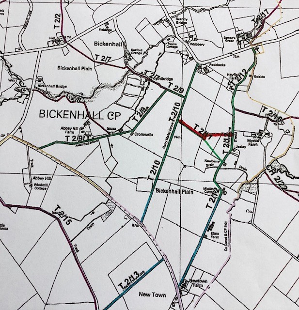
Note: The T2/11 right of way is shown in green. The new route, shown in red, is a combination of a part of the right of way, and a permissive bridleway.
Note: Because of the scale of the map, it is difficult to show that the permissive bridleway turns left immediately after it branches from the right of way. It then runs beside a hedge for a short distance before turning right to follow another hedge, and onwards towards the gate onto Forest Drove. This section is both clearly signed, and bounded by a single wire fence, to show the direction to take.
The reason for the use of a permissive path is two-fold.
First, both landowners have lodged an application to have the public right of way of the bridleway (T2/11) removed from Somerset Council’s Definitive Map*.
Second, an application has been made to divert the Forest Drove end of the right of way onto the line taken by the new permissive bridleway.
Both actions will take time to be processed. If the application to remove T2/11 were to fail, and the application to divert the right of way succeed, then newly created route would become the T2/11 right of way.
*For further information on public rights of way matters, including requests to remove or divert a right of way, and the definitive map, please click https://www.somerset.gov.uk/roads-travel-and-parking/public-rights-of-way/
*To view the Somerset Definitive Map, and the line of the right of way of T2/11 Bridleway, please click https://roam.somerset.gov.uk/roam/map
The Rights of Way Department deserve praise for providing a bridleway for public use while the above legal matters are resolved. Also, for the quality of the work it carried out. The gates are wide, and well hung, and allow easy access for families with children, dog walkers and many with disabilities. The surface is grassed so good footwear is advised in wet conditions.
